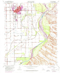
1970 Map of Blythe
USGS Topo · Published 1975About this map
The Colorado River defines the border between California and Arizona, serving as the central axis for this 1970 revision. On the western bank, Blythe and East Blythe show significant urban growth, supported by a sophisticated irrigation network including the Palo Verde Intake and various channels like the C Canal and D-10 Canal. This infrastructure transformed the arid valley into a productive agricultural region. Across the Ehrenberg Bridge in Arizona, the smaller settlement of Ehrenberg sits near the Ehrenberg Cemetery, surrounded by the desert terrain of Limekiln Wash and Weaver Wash.
Find a feature on this map
39 named features on this map. Tap any name to fly to it.
Don’t see what you’re looking for? This feature index may not catch every label — zoom into the map to look around manually.
Map Details
Editions of this 1970 Blythe Map
This is the sole edition of this map. No revisions or reprints were ever made.
Other maps of this area

1933 · Cunningham Mtn
USGS Topo · 1:48,000

1934 · Trigo Peaks
USGS Topo · 1:48,000

1939 · Trigo Peaks
USGS Topo · 1:62,500

1940 · Dome Rock Mts
USGS Topo · 1:62,500

1942 · Blythe
USGS Topo · 1:250,000

1945 · Cibola
USGS Topo · 1:62,500

1951 · Blythe
USGS Topo · 1:24,000

1951 · McCoy Wash
USGS Topo · 1:24,000

1951 · Blythe NE
USGS Topo · 1:24,000

1951 · Cibola
USGS Topo · 1:62,500