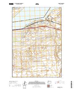
2020 Map of Boardman
USGS Topo · Published 2020About this map
Boardman sits at the heart of this survey, positioned along the southern banks of Lake Umatilla and the North Channel Columbia River. This landscape is defined by the critical infrastructure of the river and the irrigation networks that sustain it, including the W Extension Irrigation Canal and the Boardman Canal Ln. To the north, the river is divided by Whitcomb Island, while the Messinger Lower Range, Messinger Middle Range, and Messinger Upper Range provide navigational landmarks for the waterway.
Find a feature on this map
56 named features on this map. Tap any name to fly to it.
Don’t see what you’re looking for? This feature index may not catch every label — zoom into the map to look around manually.
Map Details
Editions of this 2020 Boardman Map
This is the sole edition of this map. No revisions or reprints were ever made.
Other maps of this area

1906 · Blalock Island
USGS Topo · 1:125,000

1908 · Blalock Island
USGS Topo · 1:125,000

1953 · Pendleton
USGS Topo · 1:250,000

1956 · Pendleton
USGS Topo · 1:250,000

1962 · Canoe Ridge
USGS Topo · 1:24,000

1962 · Blalock Island
USGS Topo · 1:24,000

1962 · Paterson
USGS Topo · 1:24,000

1962 · Boardman
USGS Topo · 1:24,000

1962 · Clarke
USGS Topo · 1:24,000

1962 · Crow Butte
USGS Topo · 1:24,000