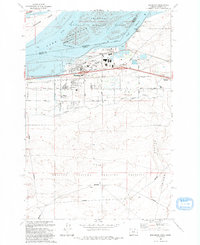
1993 Map of Boardman
USGS Topo · Published 1993About this map
Lake Umatilla dominates the northern landscape of this 1993 edition, where the Columbia River serves as the boundary between Benton and Morrow counties. The city of Boardman serves as the central hub, showing significant infrastructure including the Port of Morrow and a Filtration Plant. South of the residential core, the landscape transitions from irrigated agricultural plots near the West Extension Irrigation Canal to the expansive Naval Weapons Systems Training Facility, which occupies the southern half of the quadrangle. For those tracing local heritage, the Riverview Cem is located near the riverfront, and the Union Pacific railroad corridor tracks through Messner and Boardman Junction. The map also preserves the northern ecological setting of the Umatilla National Wildlife Refuge, featuring several island formations such as Whitcomb Island situated within the river's North Channel.
Find a feature on this map
35 named features on this map. Tap any name to fly to it.
Don’t see what you’re looking for? This feature index may not catch every label — zoom into the map to look around manually.
Map Details
Editions of this 1993 Boardman Map
This is the sole edition of this map. No revisions or reprints were ever made.
Other maps of this area

1906 · Blalock Island
USGS Topo · 1:125,000

1908 · Blalock Island
USGS Topo · 1:125,000

1953 · Pendleton
USGS Topo · 1:250,000

1956 · Pendleton
USGS Topo · 1:250,000

1962 · Canoe Ridge
USGS Topo · 1:24,000

1962 · Blalock Island
USGS Topo · 1:24,000

1962 · Paterson
USGS Topo · 1:24,000

1962 · Boardman
USGS Topo · 1:24,000

1962 · Clarke
USGS Topo · 1:24,000

1962 · Crow Butte
USGS Topo · 1:24,000