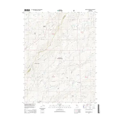
2015 Map of Boards Crossing
USGS Topo · Published 2015About this map
The North Fork Stanislaus River and S Fork Mokelumne River carve through this high-altitude section of the Stanislaus National Forest along the border of Calaveras and Tuolumne counties. This 2015 survey details a landscape defined by significant elevation changes, from the heights of Summit Level Ridge and Thunder Hill down to the drainage of Grizzly Cr. The small settlements of Cottage Springs and Cedar Flat appear near the northern and central portions of the map, while Boards Crossing serves as a critical point on the river. A dense network of Forest Service routes, such as Forest Rte 6N80 and Boards Crossing Rd, provides access across the complex terrain. Water sources like Cottage Spring and Burnt Corral Spring suggest the area's importance for local resource management and recreation.
Find a feature on this map
50 named features on this map. Tap any name to fly to it.
Don’t see what you’re looking for? This feature index may not catch every label — zoom into the map to look around manually.
Map Details
Editions of this 2015 Boards Crossing Map
This is the sole edition of this map. No revisions or reprints were ever made.
Other maps of this area

1891 · Big Trees
USGS Topo · 1:125,000

1894 · Big Trees
USGS Topo · 1:125,000

1897 · Big Trees
USGS Topo · 1:125,000

1901 · Big Trees
USGS Topo · 1:125,000

1947 · Sacramento
USGS Topo · 1:250,000

1948 · Sacramento
USGS Topo · 1:250,000

1948 · Columbia
USGS Topo · 1:62,500

1948 · Stanislaus
USGS Topo · 1:24,000
1949 · Stanislaus
USGS Topo · 1:24,000

1956 · Sacramento
USGS Topo · 1:250,000