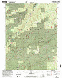
2001 Map of Boards Crossing
USGS Topo · Published 2004About this map
The North Fork Stanislaus River carves a deep path through this portion of the Stanislaus National Forest, marking the boundary between Calaveras and Tuolumne counties. At the turn of the millennium, the landscape was a mosaic of active recreation and historical memory, featuring the Cottage Springs ski area alongside numerous historical sites. To the south, the massive giants of Calaveras Big Trees State Park stand near Windy Gap and the Repeater Hill installation. The map documents several named cabin sites and encampments, such as Brown Girl Cabin and Brown Boy Cabin, which alongside Whittles Upper Camp, suggest a long history of seasonal mountain occupation. Moving toward the river, the Sourgrass Recreation Area and Wakaluu Hepyoo Campground highlight the area's continued importance for public access near the water.
Find a feature on this map
42 named features on this map. Tap any name to fly to it.
Don’t see what you’re looking for? This feature index may not catch every label — zoom into the map to look around manually.
Map Details
Editions of this 2001 Boards Crossing Map
This is the sole edition of this map. No revisions or reprints were ever made.
Other maps of this area

1891 · Big Trees
USGS Topo · 1:125,000

1894 · Big Trees
USGS Topo · 1:125,000

1897 · Big Trees
USGS Topo · 1:125,000

1901 · Big Trees
USGS Topo · 1:125,000

1947 · Sacramento
USGS Topo · 1:250,000

1948 · Sacramento
USGS Topo · 1:250,000

1948 · Columbia
USGS Topo · 1:62,500

1948 · Stanislaus
USGS Topo · 1:24,000
1949 · Stanislaus
USGS Topo · 1:24,000

1956 · Sacramento
USGS Topo · 1:250,000