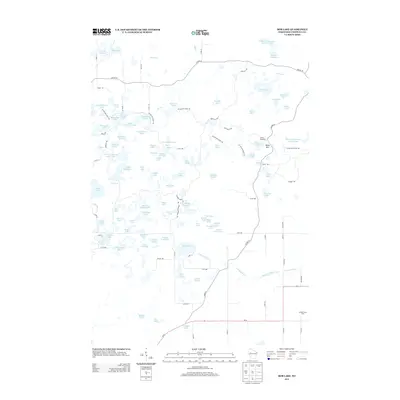
2013 Map of Bob Lake
USGS Topo · Published 2013About this map
Glacial topography and water management systems define this portion of Chippewa County, characterized by a high density of kettle lakes and managed flowages. The winding path of the Ice Age Natl Scenic Trl traverses the northern and central sections, following the moraine ridges near Baldy Mtn. This recreational landscape is anchored by Camp Nawakwa and an extensive network of specialized paths including the High Ridge Trl and Hay Meadow Flowage Trl. To the south, the landscape transitions to agricultural use near Spring Creek Dairy, where the terrain flattens toward Wi-64. Numerous small water bodies like Knickerbocker Lake, Boiler Lake, and Bob Lake illustrate the complex hydrography of the region, while man-made features such as Willow Cr Flowage 3 demonstrate the historical modification of the Willow Cr watershed.
Find a feature on this map
115 named features on this map. Tap any name to fly to it.
Don’t see what you’re looking for? This feature index may not catch every label — zoom into the map to look around manually.
Map Details
Editions of this 2013 Bob Lake Map
This is the sole edition of this map. No revisions or reprints were ever made.
Other maps of this area

1948 · Weyerhauser
USGS Topo · 1:48,000

1948 · Ladysmith
USGS Topo · 1:48,000

1949 · Bloomer
USGS Topo · 1:62,500

1950 · Weyerhauser
USGS Topo · 1:48,000

1950 · Ladysmith
USGS Topo · 1:48,000

1951 · Bloomer
USGS Topo · 1:62,500

1951 · Cornell
USGS Topo · 1:62,500

1953 · Rice Lake
USGS Topo · 1:250,000

1959 · Rice Lake
USGS Topo · 1:250,000
1971 · Flambeau Ridge
USGS Topo · 1:24,000