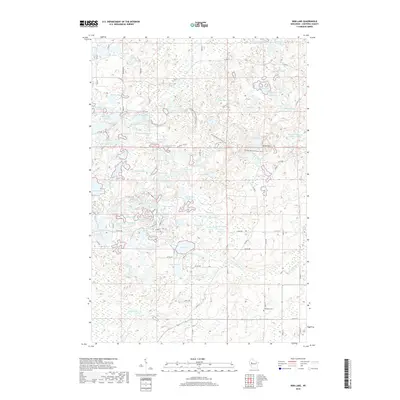
2018 Map of Bob Lake
USGS Topo · Published 2018About this map
Glacial topography and intricate water networks define this portion of Chippewa County, where the Ice Age National Scenic Trail winds through a dense cluster of kettle lakes and flowages. The landscape is characterized by its high density of small water bodies, including Triple Lakes, Riley Lake, and the distinctly named Boiler Lake. In the northern section, man-made hydrology is evident in the Willow Cr Flowage Number Two and Willow Cr Flowage 3, which manage the waters of Willow Cr.
Find a feature on this map
109 named features on this map. Tap any name to fly to it.
Don’t see what you’re looking for? This feature index may not catch every label — zoom into the map to look around manually.
Map Details
Editions of this 2018 Bob Lake Map
This is the sole edition of this map. No revisions or reprints were ever made.
Other maps of this area

1948 · Weyerhauser
USGS Topo · 1:48,000

1948 · Ladysmith
USGS Topo · 1:48,000

1949 · Bloomer
USGS Topo · 1:62,500

1950 · Weyerhauser
USGS Topo · 1:48,000

1950 · Ladysmith
USGS Topo · 1:48,000

1951 · Bloomer
USGS Topo · 1:62,500

1951 · Cornell
USGS Topo · 1:62,500

1953 · Rice Lake
USGS Topo · 1:250,000

1959 · Rice Lake
USGS Topo · 1:250,000
1971 · Flambeau Ridge
USGS Topo · 1:24,000