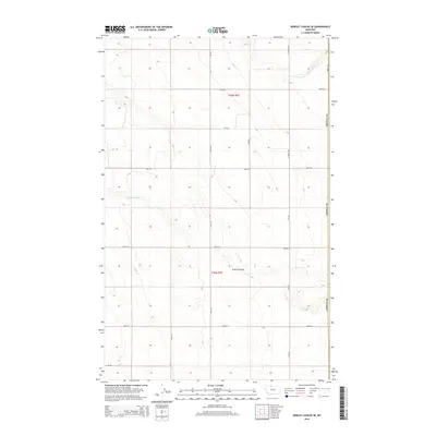
2014 Map of Bobcat Coulee SE
USGS Topo · Published 2014About this map
Tempel Reservoir sits at the head of a drainage system in this high plains region of Hill County, where the landscape is defined by the deep incision of Scotch Coulee. The map reveals a strictly organized agricultural grid, with section lines and section corners marked by an extensive network of numbered rural roads such as 1000 Rd S and 2000 Rd E. This 2014 survey documents the persistence of the Public Land Survey System in the Missouri River watershed, where the boundary with Liberty Co runs north-south along the eastern edge of the quadrangle. Transportation is anchored by Mt-224 and the intersecting N Joplin Rd, which serve as the primary conduits for the area's farming and ranching economy. The presence of Haul Rd suggests more specialized transit routes within the township and range divisions of t36n r7e.
Find a feature on this map
18 named features on this map. Tap any name to fly to it.
Don’t see what you’re looking for? This feature index may not catch every label — zoom into the map to look around manually.
Map Details
Editions of this 2014 Bobcat Coulee SE Map
This is the sole edition of this map. No revisions or reprints were ever made.
Other maps of this area

1919 · Alma
USGS Topo · 1:125,000

1954 · Shelby
USGS Topo · 1:250,000

1958 · Shelby
USGS Topo · 1:250,000

1963 · Bobcat Coulee SE
USGS Topo · 1:24,000

1963 · Vaver Reservoir
USGS Topo · 1:24,000

1963 · Chester NW
USGS Topo · 1:24,000

1963 · Chester NE
USGS Topo · 1:24,000
1964 · Bobcat Coulee NE
USGS Topo · 1:24,000
1964 · Laird School
USGS Topo · 1:24,000

1972 · Goldstone SW
USGS Topo · 1:24,000