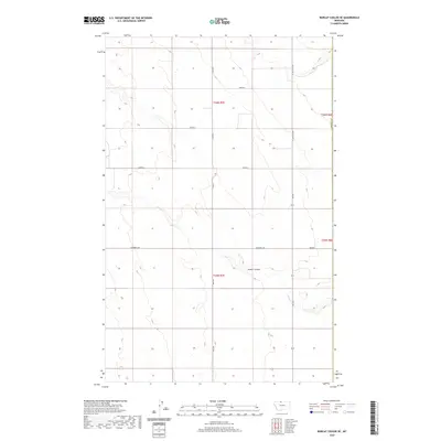
2020 Map of Bobcat Coulee SE
USGS Topo · Published 2020About this map
Scotch Coulee winds through this expanse of northern Montana, providing a natural drainage corridor across an otherwise geometric landscape of section lines and gravel roads. Located along the border of Hill and Liberty counties, the area is defined by its agricultural grid, where arterial routes like Fas 224 and N Joplin Co Rd connect remote farmsteads and field access points. The network of secondary roads, including McDowell Rd and Haul Rd, illustrates the methodical division of the High Line's prairie into the townships of T36N R7E and T35N R7E. This survey preserves the exact placement of local infrastructure, from numbered county routes like 1000 Rd S to the subtle variations in elevation that define the coulee's path, making it an essential reference for understanding contemporary land use and property boundaries in this rural section of the state.
Find a feature on this map
15 named features on this map. Tap any name to fly to it.
Don’t see what you’re looking for? This feature index may not catch every label — zoom into the map to look around manually.
Map Details
Editions of this 2020 Bobcat Coulee SE Map
This is the sole edition of this map. No revisions or reprints were ever made.
Other maps of this area

1919 · Alma
USGS Topo · 1:125,000

1954 · Shelby
USGS Topo · 1:250,000

1958 · Shelby
USGS Topo · 1:250,000

1963 · Bobcat Coulee SE
USGS Topo · 1:24,000

1963 · Vaver Reservoir
USGS Topo · 1:24,000

1963 · Chester NW
USGS Topo · 1:24,000

1963 · Chester NE
USGS Topo · 1:24,000
1964 · Bobcat Coulee NE
USGS Topo · 1:24,000
1964 · Laird School
USGS Topo · 1:24,000

1972 · Goldstone SW
USGS Topo · 1:24,000