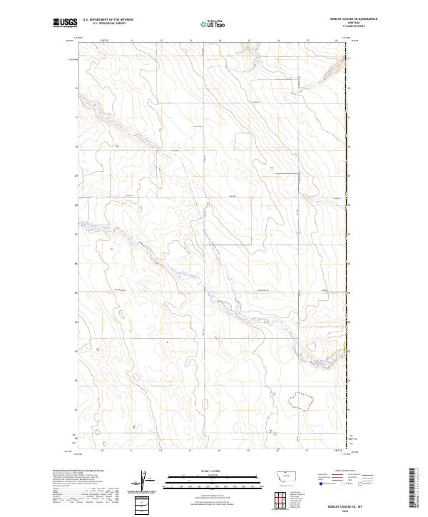
2024 Map of Bobcat Coulee SE
USGS Topo · Published 2024About this map
Little Sage Creek meanders through this portion of Liberty County, defining a landscape where seasonal waterways and agricultural access roads intersect. This modern topographical survey highlights the deep erosion patterns of Scotch Coulee, a significant drainage feature that cuts through the High Plains terrain. The section lines of the Public Land Survey System are clearly marked across townships T35N and T36N, reflecting the systematic organization of Montana's rural reaches. Connectivity is maintained through a network of rural routes, including Fas 224, McDowell Rd, and specialized paths such as Haul Rd, which illustrate the ongoing agricultural and industrial use of this sparsely populated region. The topography is characterized by subtle elevation shifts and winding stream beds, typical of the northern Montana prairie.
Find a feature on this map
15 named features on this map. Tap any name to fly to it.
Don’t see what you’re looking for? This feature index may not catch every label — zoom into the map to look around manually.
Map Details
Editions of this 2024 Bobcat Coulee SE Map
This is the sole edition of this map. No revisions or reprints were ever made.
Other maps of this area

1919 · Alma
USGS Topo · 1:125,000

1954 · Shelby
USGS Topo · 1:250,000

1958 · Shelby
USGS Topo · 1:250,000

1963 · Bobcat Coulee SE
USGS Topo · 1:24,000

1963 · Vaver Reservoir
USGS Topo · 1:24,000

1963 · Chester NW
USGS Topo · 1:24,000

1963 · Chester NE
USGS Topo · 1:24,000
1964 · Bobcat Coulee NE
USGS Topo · 1:24,000
1964 · Laird School
USGS Topo · 1:24,000

1972 · Goldstone SW
USGS Topo · 1:24,000