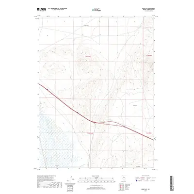
2018 Map of Bobs Flat
USGS Topo · Published 2018About this map
Humboldt River waters flow through the southwestern portion of this Eureka County landscape, defining the character of the Whirlwind Valley. The presence of the Merchant Canal and Anderson Canal reflects the long-standing management of water in this arid basin, likely supporting livestock or irrigation efforts in an area dominated by wide alluvial expanses. To the north and east, the terrain transitions into the broad basins of Boulder Flat and Bobs Flat, framed by drainage features like Mack Cr and Bob Cr. The modern path of Interstate 80 and State Route 306 cut through the heart of these flats, following natural corridors used by travelers since the mid-19th century. This topography reveals the classic Basin and Range structure, where flat valley floors meet the sharp rise of surrounding uplands, punctuated by the seasonal runoff path of Long Draw.
Find a feature on this map
15 named features on this map. Tap any name to fly to it.
Don’t see what you’re looking for? This feature index may not catch every label — zoom into the map to look around manually.
Map Details
Editions of this 2018 Bobs Flat Map
This is the sole edition of this map. No revisions or reprints were ever made.
Other maps of this area

1955 · Winnemucca
USGS Topo · 1:250,000

1957 · Dunphy
USGS Topo · 1:62,500

1957 · Beowawe
USGS Topo · 1:62,500

1958 · Winnemucca
USGS Topo · 1:250,000

1962 · Winnemucca
USGS Topo · 1:250,000

1965 · Sheep Creek Range SE
USGS Topo · 1:24,000

1968 · Rodeo Creek SW
USGS Topo · 1:24,000

1968 · Welches Canyon
USGS Topo · 1:24,000

1985 · Scotts Gulch
USGS Topo · 1:24,000
1985 · The Geysers
USGS Topo · 1:24,000