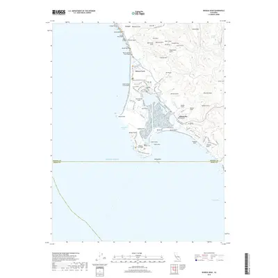
2018 Map of Bodega Head
USGS Topo · Published 2018About this map
Bodega Bay and the surrounding coastline of Sonoma County are defined by the geological transition at the San Andreas Fault, which cuts directly through the harbor. This modern survey shows the residential expansion of coastal settlements like Carmet and Salmon Creek against the complex terrain of the Pacific shoreline. The peninsula at Bodega Head remains a central landmark, featuring the curious excavation site known as Hole in the Head and the protected waters of Campbell Cove.
Find a feature on this map
86 named features on this map. Tap any name to fly to it.
Don’t see what you’re looking for? This feature index may not catch every label — zoom into the map to look around manually.
Map Details
Editions of this 2018 Bodega Head Map
This is the sole edition of this map. No revisions or reprints were ever made.
Other maps of this area

1916 · Point Reyes
USGS Topo · 1:48,000

1918 · Point Reyes
USGS Topo · 1:62,500

1935 · Sebastopol
USGS Topo · 1:48,000

1942 · Sebastopol
USGS Topo · 1:62,500

1942 · Bodega Head
USGS Topo · 1:24,000

1942 · Arched Rock
USGS Topo · 1:24,000

1943 · Duncans Mills
USGS Topo · 1:24,000

1944 · Bodega Head
USGS Topo · 1:31,680
1944 · Arched Rock
USGS Topo · 1:31,680
1945 · Duncans Mills
USGS Topo · 1:31,680