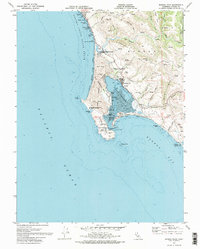
1972 Map of Bodega Head
USGS Topo · Published 1974About this map
Bodega Harbor and its distinctive sheltering peninsula form the centerpiece of this coastal survey, which documents the shoreline during the early 1970s. The geologically significant San Andreas Rift Zone is clearly marked as it traverses the narrow neck of land between the harbor and the sea, creating the unique topography of Bodega Head. This era shows the developed waterfront of Bodega Bay and the nearby Salmon Creek settlement, alongside scientific and public infrastructure like the University of California Marine Laboratory and Doran County Park. Inland, the landscape rises toward Mount Roscoe and Sheep Ridge, dissected by numerous gulches such as Cheney Gulch and Johnson Gulch. The map records a balance of recreational coastal use at Sonoma Coast State Beach and localized industry, evidenced by a Quarry and various utility substations.
Find a feature on this map
50 named features on this map. Tap any name to fly to it.
Don’t see what you’re looking for? This feature index may not catch every label — zoom into the map to look around manually.
Map Details
Editions of this 1972 Bodega Head Map
2 editions found
Other maps of this area

1916 · Point Reyes
USGS Topo · 1:48,000

1918 · Point Reyes
USGS Topo · 1:62,500

1935 · Sebastopol
USGS Topo · 1:48,000

1942 · Sebastopol
USGS Topo · 1:62,500

1942 · Bodega Head
USGS Topo · 1:24,000

1942 · Arched Rock
USGS Topo · 1:24,000

1943 · Duncans Mills
USGS Topo · 1:24,000

1944 · Bodega Head
USGS Topo · 1:31,680
1944 · Arched Rock
USGS Topo · 1:31,680
1945 · Duncans Mills
USGS Topo · 1:31,680