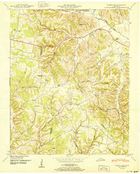
1950 Map of Bodenham
USGS Topo · Published 1950About this map
Bodenham sits at the intersection of rural life and natural topography along U.S. 64 in Giles County. This 1950 Tennessee Valley Authority study reveals a landscape densely carved by drainages like Choate Creek and Hurricane Creek, where settlement followed the ridges and narrow valleys. Local history is anchored by numerous rural institutions, including the Beech Grove Ch and Choate Creek Church, alongside several schools such as Bodenham Sch and Union Hill School. The map is particularly valuable for genealogists, as it identifies several family-named landmarks and resting places like Hughes Cem and Smith Cem. Distinctive terrain features such as Powder Mill Hill and the Tin Top summit provide context for the early road networks and small communities like New Prospect and Fall River that flourished in the mid-century South.
Find a feature on this map
74 named features on this map. Tap any name to fly to it.
Don’t see what you’re looking for? This feature index may not catch every label — zoom into the map to look around manually.
Map Details
Editions of this 1950 Bodenham Map
This is the sole edition of this map. No revisions or reprints were ever made.
Other maps of this area

1936 · Milky Way
USGS Topo · 1:24,000

1936 · Aspen Hill
USGS Topo · 1:24,000

1936 · Campbellsville
USGS Topo · 1:24,000

1936 · Lawrenceburg
USGS Topo · 1:24,000

1936 · Ethridge
USGS Topo · 1:24,000

1936 · Pulaski
USGS Topo · 1:24,000

1936 · Bodenham
USGS Topo · 1:24,000

1936 · Appleton
USGS Topo · 1:24,000

1936 · Bonnertown
USGS Topo · 1:24,000
1948 · Appleton
USGS Topo · 1:24,000