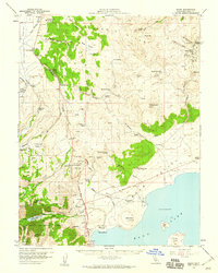
1958 Map of Bodie
USGS Topo · Published 1959About this map
The high desert landscape of the Bodie Hills dominates this 1958 topographic study, captured shortly before the region’s legendary mining sites were further preserved. The northeast corner centers on the historic mining district near Bodie Bluff and Silver Hill, where the Bodie Cem and the Red Cloud Mine remain as physical markers of the 19th-century boom. The mapping of the Geiser Grade and various prospects illustrates the intensive extraction history that defined this area. To the south, the waters of Mono Lake emerge, featuring Paoha Island and Negit Island. A series of ranching operations, such as Mormon Ranch and Conway Ranch, indicate the agricultural life that persisted in the lower meadows and valleys like Mono Valley and Sinnamon Meadow.
Find a feature on this map
76 named features on this map. Tap any name to fly to it.
Don’t see what you’re looking for? This feature index may not catch every label — zoom into the map to look around manually.
Map Details
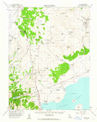
Editions of this 1958 Bodie Map
3 editions found

Other maps of this area

1901 · Mt. Lyell
USGS Topo · 1:125,000

1909 · Hawthorne
USGS Topo · 1:250,000

1909 · Bridgeport
USGS Topo · 1:125,000

1911 · Bridgeport
USGS Topo · 1:125,000

1911 · Hawthorne
USGS Topo · 1:250,000

1914 · Mt. Morrison
USGS Topo · 1:125,000

1915 · Hawthorne
USGS Topo · 1:250,000

1920 · Bridgeport
USGS Topo · 1:125,000

1947 · Mariposa
USGS Topo · 1:250,000

1948 · Walker Lake
USGS Topo · 1:250,000