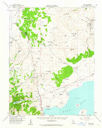
1958 Map of Bodie
USGS Topo · Published 1964About this map
Bodie stands as the prominent settlement in the high desert of the Bodie Hills, surrounded by evidence of a busy mining and ranching economy in the late 1950s. The landscape is marked by historic industry, from the Red Cloud Mine and Little Bodie Mine to the Dunderberg Mill near Sinnamon Meadow. Genealogists will find the Bodie Cem and various Graves recorded, alongside family-named locations such as Conway Ranch, Mormon Ranch, and Dechambeau Ranch. To the south, the waters of Mono Lake reveal Paoha Island and Negit Island, while the western edge is defined by the steep terrain of the Toiyabe National Forest. The map captures a complex network of resource extraction and high-altitude agriculture, illustrated by irrigation features like Sinnamon Cut and the presence of the Powerhouse near Lundy Lake.
Find a feature on this map
87 named features on this map. Tap any name to fly to it.
Don’t see what you’re looking for? This feature index may not catch every label — zoom into the map to look around manually.
Map Details
Editions of this 1958 Bodie Map
3 editions found

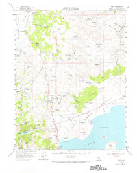
Other maps of this area

1901 · Mt. Lyell
USGS Topo · 1:125,000

1909 · Hawthorne
USGS Topo · 1:250,000

1909 · Bridgeport
USGS Topo · 1:125,000

1911 · Bridgeport
USGS Topo · 1:125,000

1911 · Hawthorne
USGS Topo · 1:250,000

1914 · Mt. Morrison
USGS Topo · 1:125,000

1915 · Hawthorne
USGS Topo · 1:250,000

1920 · Bridgeport
USGS Topo · 1:125,000

1947 · Mariposa
USGS Topo · 1:250,000

1948 · Walker Lake
USGS Topo · 1:250,000