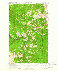
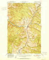
1958 Map of Bodie Mtn
USGS Topo · Published 1961About this map
The Canada United States border forms the northern limit of this late-1950s survey, where the peaks of the Okanogan National Forest and Colville National Forest meet. The mining legacy of the region is evident in the numerous operations scattered across the high country, including the Magnetic Mine near Buckhorn Mtn and the Silver Bell Mine further south. Settlement is clustered along the waterways, with Toroda situated at the bend of the Kettle River, while Bodie and Old Toroda mark the path of Toroda Creek. The map documents a rugged landscape of active lookouts and remote camps, such as Bodie Mtn Lookout and Gold Axe Camp. A small Cem near the river and the presence of a Ferry crossing into British Columbia highlight the area's role as a transit point for local industry and residents during this era.
Find a feature on this map
66 named features on this map. Tap any name to fly to it.
Don’t see what you’re looking for? This feature index may not catch every label — zoom into the map to look around manually.
Map Details
Editions of this 1958 Bodie Mtn Map
This is the sole edition of this map. No revisions or reprints were ever made.
Other maps of this area

1902 · Osoyoos
USGS Topo · 1:125,000

1904 · Osoyoos
USGS Topo · 1:125,000

1904 · Republic
USGS Topo · 1:125,000
1948 · Curlew
USGS Topo · 1:62,500
1948 · Republic
USGS Topo · 1:62,500
1951 · Wauconda
USGS Topo · 1:62,500
1951 · Curlew
USGS Topo · 1:62,500

1951 · Bodie Mountain
USGS Topo · 1:62,500
1951 · Republic
USGS Topo · 1:62,500

1954 · Okanogan
USGS Topo · 1:250,000