
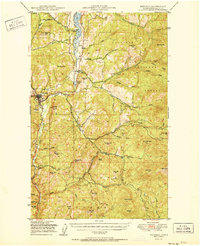
1951 Map of Republic
USGS Topo · Published 1951About this map
The town of Republic sits at the heart of this post-war survey, serving as a hub for the mining and timber interests of the Colville National Forest. The landscape is dominated by the drainage of the Sanpoil River and its numerous forks, which provided essential water routes for early industrial activity. Evidence of the region’s mineral wealth is seen at the California Mine and the rugged peaks of Gibraltar Mtn and Gold Hill.
Find a feature on this map
55 named features on this map. Tap any name to fly to it.
Don’t see what you’re looking for? This feature index may not catch every label — zoom into the map to look around manually.
Map Details
Editions of this 1951 Republic Map
2 editions found
Other maps of this area

1904 · Republic
USGS Topo · 1:125,000

1936 · Marcus
USGS Topo · 1:96,000

1942 · Marcus
USGS Topo · 1:125,000

1948 · Curlew
USGS Topo · 1:62,500

1948 · Republic
USGS Topo · 1:62,500

1948 · Sherman Peak
USGS Topo · 1:62,500

1948 · Togo Mountain
USGS Topo · 1:62,500

1951 · Wauconda
USGS Topo · 1:62,500

1951 · Togo Mountain
USGS Topo · 1:62,500

1951 · Sherman Peak
USGS Topo · 1:62,500