
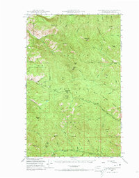
1948 Map of Togo Mountain
USGS Topo · Published 1963About this map
Colville National Forest dominates this mid-century survey of the terrain along the international boundary. The landscape is defined by the high elevations of Mt Leona and Profanity Pk, with deep drainages such as Boulder Creek and Deer Creek cutting through the ridges. This period of forest management is evidenced by the presence of the Summit Guard Sta, a key administrative and fire-watch point for the surrounding peaks. Local human presence is sparse but distinct, marked by family-named landmarks like Ryan Cabin and Ryan Hill in the southern reaches. The network of creeks, including the North Fork Togo Creek and Little Boulder Creek, illustrates the complex hydrology that supported the region's wilderness character before more modern development altered these remote drainages. The map records the precise location of Boundary Mtn along the northern edge, anchoring the survey to the United States and Canada border.
Find a feature on this map
58 named features on this map. Tap any name to fly to it.
Don’t see what you’re looking for? This feature index may not catch every label — zoom into the map to look around manually.
Map Details
Editions of this 1948 Togo Mountain Map
2 editions found
Other maps of this area

1904 · Republic
USGS Topo · 1:125,000

1936 · Marcus
USGS Topo · 1:96,000

1942 · Marcus
USGS Topo · 1:125,000

1948 · Curlew
USGS Topo · 1:62,500

1948 · Republic
USGS Topo · 1:62,500

1948 · Sherman Peak
USGS Topo · 1:62,500

1948 · Kettle Falls
USGS Topo · 1:62,500

1948 · Orient
USGS Topo · 1:62,500

1951 · Togo Mountain
USGS Topo · 1:62,500

1951 · Sherman Peak
USGS Topo · 1:62,500