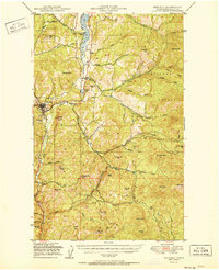
1951 Map of Republic
USGS Topo · Published 1951About this map
Republic serves as the focal point of this mountainous region within the Colville National Forest, where mining and timber interests have long shaped the landscape. The Great Northern railroad winds through the Sanpoil River valley, connecting small northern outposts like Pollard and Torboy to the county seat. This 1951 record, based on mid-1940s aerial photography, captures the era of the California Mine and the local Fairweather Airport, providing a clear view of the complex terrain before more modern development altered these drainage patterns. The map is particularly detailed regarding the multiple forks of the Sanpoil River and O'Brien Creek, illustrating a high-elevation environment defined by prominent peaks such as Gibraltar Mtn, Quartz Mtn, and Mt Washington. For those interested in local genealogy or industrial history, the inclusion of the town Cem and family-named landmarks like McMann Creek or Barrett Butte offers specific points of reference for mid-century land use.
Find a feature on this map
57 named features on this map. Tap any name to fly to it.
Don’t see what you’re looking for? This feature index may not catch every label — zoom into the map to look around manually.
Map Details
Editions of this 1951 Republic Map
2 editions found

Other maps of this area

1904 · Republic
USGS Topo · 1:125,000

1936 · Marcus
USGS Topo · 1:96,000

1942 · Marcus
USGS Topo · 1:125,000

1948 · Curlew
USGS Topo · 1:62,500

1948 · Republic
USGS Topo · 1:62,500

1948 · Sherman Peak
USGS Topo · 1:62,500

1948 · Togo Mountain
USGS Topo · 1:62,500

1951 · Wauconda
USGS Topo · 1:62,500

1951 · Togo Mountain
USGS Topo · 1:62,500

1951 · Sherman Peak
USGS Topo · 1:62,500