
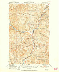
1951 Map of Curlew
USGS Topo · Published 1951About this map
The Kettle River defines the lower valley terrain in this mid-century survey, flowing through the heart of Colville National Forest and past the border settlement of Danville. The corridor is dominated by the Great Northern railroad, which follows the river's winding path from the international boundary south through Curlew and Malo. This rail-and-river network supported the local timber and mining economy, as evidenced by high-altitude vantage points like Vulcan Lookout and Franson Pk Lookout perched on surrounding summits.
Find a feature on this map
48 named features on this map. Tap any name to fly to it.
Don’t see what you’re looking for? This feature index may not catch every label — zoom into the map to look around manually.
Map Details
Editions of this 1951 Curlew Map
2 editions found
Other maps of this area

1904 · Republic
USGS Topo · 1:125,000

1936 · Marcus
USGS Topo · 1:96,000

1942 · Marcus
USGS Topo · 1:125,000

1948 · Curlew
USGS Topo · 1:62,500

1948 · Republic
USGS Topo · 1:62,500

1948 · Sherman Peak
USGS Topo · 1:62,500

1948 · Togo Mountain
USGS Topo · 1:62,500

1951 · Wauconda
USGS Topo · 1:62,500

1951 · Togo Mountain
USGS Topo · 1:62,500

1951 · Sherman Peak
USGS Topo · 1:62,500