
1895 Map of Bodreau
USGS Topo · Published 1895About this map
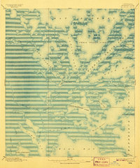
Indian Mound stands as a central landmark in this coastal landscape of St. Bernard Parish, where the complex transition from marsh to open water is meticulously charted. The map reveals an intricate network of navigable waterways including Bayou La Loutre and Bayou Petre, which weave through a series of shallow basins such as Lake Eugenie and Christmas Camp Lake. This 1895 survey captures the region long before modern coastal erosion and canal dredging significantly altered the shoreline. Notable maritime features such as Morgan Harbor and Twilight Harbor appear alongside uniquely named water bodies like Fishing Smack Lake, reflecting the local fishing and trapping culture of the Louisiana wetlands. The topography is characterized by low-lying elevations, with the entire area sitting less than five feet above sea level.
Find a feature on this map
35 named features on this map. Tap any name to fly to it.
Don’t see what you’re looking for? This feature index may not catch every label — zoom into the map to look around manually.
Map Details
Editions of this 1895 Bodreau Map
2 editions found
Other maps of this area

1893 · Cat Island
USGS Topo · 1:62,500

1893 · Rigolets
USGS Topo · 1:62,500

1893 · La Fortuna
USGS Topo · 1:62,500

1893 · Chandeleur
USGS Topo · 1:62,500

1893 · Shell Beach
USGS Topo · 1:62,500

1893 · Toulme
USGS Topo · 1:62,500

1893 · Dime
USGS Topo · 1:62,500

1935 · Morgan Harbor
USGS Topo · 1:31,680

1935 · Lake Athanasio
USGS Topo · 1:31,680

1935 · Mitchell Keys
USGS Topo · 1:31,680