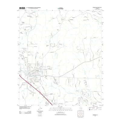
2013 Map of Boerne
USGS Topo · Published 2013About this map
Boerne serves as the focal point of this Kendall County survey, where the expanding street grid meets the winding course of Cibolo Cr and Frederick Cr. The landscape is defined by the Texas Hill Country's characteristic limestone topography, including prominent elevations such as Sabinas Mountain, Smith Hill, and Malakopf Hill. Outside the central town, smaller communities and family-named landmarks like Walnut Grove and Kreutzberg persist alongside older burial grounds including Kreutzberg Cem and Wren Cem. Transportation and community life are marked by several local hubs, from the Herff Park Fairground south of the city center to small aviation sites like Grier Airport and John Henry Key Airport. Numerous named drainages, including Browns Cr and Postoak Cr, carve through the terrain, illustrating the complex watershed that feeds the regional river systems.
Find a feature on this map
178 named features on this map. Tap any name to fly to it.
Don’t see what you’re looking for? This feature index may not catch every label — zoom into the map to look around manually.
Map Details
Editions of this 2013 Boerne Map
This is the sole edition of this map. No revisions or reprints were ever made.
Other maps of this area

1953 · Otis Ridge
USGS Topo · 1:24,000

1953 · Van Raub
USGS Topo · 1:24,000

1954 · San Antonio
USGS Topo · 1:250,000

1956 · Comfort
USGS Topo · 1:62,500

1956 · Medina Lake
USGS Topo · 1:62,500

1957 · Boerne
USGS Topo · 1:62,500

1957 · San Antonio
USGS Topo · 1:250,000

1964 · Waring
USGS Topo · 1:24,000
1964 · Kendalia
USGS Topo · 1:24,000
1964 · Sisterdale
USGS Topo · 1:24,000