
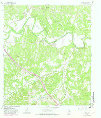
1964 Map of Waring
USGS Topo · Published 1966About this map
The Guadalupe River meanders through the heart of this Kendall County landscape, dictating the placement of early settlements and transportation routes in the mid-1960s. The Southern Pacific railroad parallels the river's course, serving the small community of Waring and passing near the local landmark of Welfare. This era shows a transition in travel as the historic Old San Antonio Road cuts through the southern terrain near Nelson City. Genealogists will find significant value in the documentation of family-named burial sites, including Brownsboro Cemetery, Insall Cem, and Zoeller Cem. The topography is defined by prominent elevations such as Jungfrau and Schleicher Mountain, while the drainage network includes Big Joshua Creek and Flat Rock Creek, illustrating the complex watershed that feeds into the main river valley.
Find a feature on this map
28 named features on this map. Tap any name to fly to it.
Don’t see what you’re looking for? This feature index may not catch every label — zoom into the map to look around manually.
Map Details
Editions of this 1964 Waring Map
2 editions found
Other maps of this area

1894 · Fredericksburg
USGS Topo · 1:125,000

1954 · Llano
USGS Topo · 1:250,000

1954 · San Antonio
USGS Topo · 1:250,000

1955 · Llano
USGS Topo · 1:250,000

1956 · Comfort
USGS Topo · 1:62,500

1956 · Llano
USGS Topo · 1:250,000

1957 · Boerne
USGS Topo · 1:62,500

1957 · San Antonio
USGS Topo · 1:250,000

1963 · Whitworth Ranch
USGS Topo · 1:24,000

1964 · Comfort
USGS Topo · 1:24,000