
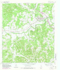
1964 Map of Comfort
USGS Topo · Published 1966About this map
Comfort serves as the central hub of this mid-1960s survey, situated at the confluence of Cypress Creek and the Guadalupe River. The settlement pattern reflects a reliance on the Southern Pacific rail line and a network of watercourses that divide the terrain into distinct bluffs and peaks. Local history is deeply embedded in the landscape through features like the Hermann Sons Cem and San Jose Cem, while the presence of a Rodeo Ground and Landing Strip near the town center indicates a mix of traditional ranching culture and modernizing infrastructure. To the northwest, the map documents the smaller locality of Wolkenburg, set against a backdrop of prominent heights such as Target Hill and Gaddis Bluff. The southern portion of the quadrangle is dominated by the intricate drainage systems of Bruins Creek and Holliday Creek, showcasing the transition from river valley to the limestone hills of the Texas Hill Country.
Find a feature on this map
26 named features on this map. Tap any name to fly to it.
Don’t see what you’re looking for? This feature index may not catch every label — zoom into the map to look around manually.
Map Details
Editions of this 1964 Comfort Map
2 editions found
Other maps of this area

1894 · Fredericksburg
USGS Topo · 1:125,000

1894 · Kerrville
USGS Topo · 1:125,000

1954 · Llano
USGS Topo · 1:250,000

1954 · San Antonio
USGS Topo · 1:250,000

1955 · Llano
USGS Topo · 1:250,000

1956 · Comfort
USGS Topo · 1:62,500

1956 · Center Point
USGS Topo · 1:62,500

1956 · Llano
USGS Topo · 1:250,000

1957 · San Antonio
USGS Topo · 1:250,000

1964 · Waring
USGS Topo · 1:24,000