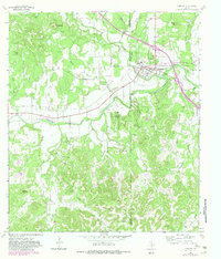
1964 Map of Comfort
USGS Topo · Published 1982About this map
The Comfort settlement sits at a strategic bend where Cypress Creek meets the Guadalupe River, serving as a central hub for this portion of the Texas Hill Country. The landscape is defined by its dramatic elevation changes, moving from the river bottomlands up to prominent heights like Bachelor Mountain, Mount Rigli, and Target Hill. Notable local history is recorded in the town’s cemeteries, including the San Jose Cem and Hermann Sons Cem, while the regional infrastructure is evidenced by the Old Railroad Grade and various gravel pits near the river. This 1964 survey, revised in the early 1980s, highlights the drainage patterns of numerous named tributaries such as Bruins Creek, Holliday Creek, and Wilson Creek that cut through the limestone bluffs. The map captures a moment when rural landmarks like the Water Tank and Gaging Sta remained essential features of the localized topography.
Find a feature on this map
26 named features on this map. Tap any name to fly to it.
Don’t see what you’re looking for? This feature index may not catch every label — zoom into the map to look around manually.
Map Details
Editions of this 1964 Comfort Map
2 editions found
Other maps of this area

1894 · Fredericksburg
USGS Topo · 1:125,000

1894 · Kerrville
USGS Topo · 1:125,000

1954 · Llano
USGS Topo · 1:250,000

1954 · San Antonio
USGS Topo · 1:250,000

1955 · Llano
USGS Topo · 1:250,000

1956 · Comfort
USGS Topo · 1:62,500

1956 · Center Point
USGS Topo · 1:62,500

1956 · Llano
USGS Topo · 1:250,000

1957 · San Antonio
USGS Topo · 1:250,000

1964 · Comfort
USGS Topo · 1:24,000