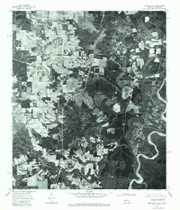
1976 Map of Bogalusa NE
USGS Topo · Published 1977About this map
Angie and Varnado anchor this 1976 orthophotoquad, which reveals the land-use patterns of Washington Parish during a period of transition. The imagery provides a direct look at the relationship between agriculture and the dense timberland characteristic of the region. The eastern boundary is defined by the winding course of the Pearl River, where the serpentine bends and oxbows contrast sharply with the geometric grid of cleared fields and roads near the settlements. This photographic record, prepared by the Geological Survey and the Louisiana Department of Public Works, serves as a precise baseline for researchers tracing the evolution of rural property lines, woodlots, and small-town footprints in the late twentieth century.
Find a feature on this map
3 named features on this map. Tap any name to fly to it.
Don’t see what you’re looking for? This feature index may not catch every label — zoom into the map to look around manually.
Map Details
Editions of this 1976 Bogalusa NE Map
This is the sole edition of this map. No revisions or reprints were ever made.
Other maps of this area

1949 · Bogalusa East
USGS Topo · 1:31,680

1949 · Angie
USGS Topo · 1:31,680

1949 · Bogalusa West
USGS Topo · 1:31,680

1950 · Crains Creek
USGS Topo · 1:31,680

1953 · Hattiesburg
USGS Topo · 1:250,000

1953 · Mobile
USGS Topo · 1:250,000

1957 · Mobile
USGS Topo · 1:250,000

1958 · Hattiesburg
USGS Topo · 1:250,000

1959 · Bogalusa
USGS Topo · 1:62,500

1959 · Poplarville
USGS Topo · 1:62,500