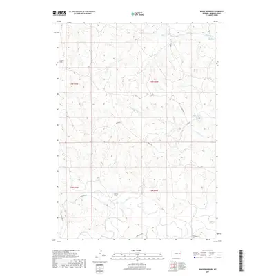
2017 Map of Boggy Reservoir
USGS Topo · Published 2017About this map
Boggy Reservoir and the adjacent Boggy Cr define the northern drainages of this Niobrara County landscape, where the high plains terrain is carved by complex water systems. Further south, the map details the significant catchment area of East Number 1 Beardsley Reservoir and its companion Beardsley Reservoir. The geography is characterized by prominent relief features like Greasewood Ridge and named ephemeral drainages including Clayton Draw and Marcus Draw. A sparse network of ranch roads, such as Redbird Rd and Wasserburger Rd, connects these remote watersheds. The southern extent is dominated by the meandering path of Lance Creek and its tributary Dogie Cr, illustrating the vital role of these seasonal water sources in supporting the regional cattle-ranching economy.
Find a feature on this map
21 named features on this map. Tap any name to fly to it.
Don’t see what you’re looking for? This feature index may not catch every label — zoom into the map to look around manually.
Map Details
Editions of this 2017 Boggy Reservoir Map
This is the sole edition of this map. No revisions or reprints were ever made.
Other maps of this area

1955 · Newcastle
USGS Topo · 1:250,000

1958 · Newcastle
USGS Topo · 1:250,000

1981 · Horseshoe Bend
USGS Topo · 1:24,000

1981 · Threemile Butte
USGS Topo · 1:24,000

1981 · Dixon Ranch
USGS Topo · 1:24,000

1981 · Lance Creek NW
USGS Topo · 1:24,000
1981 · Boggy Reservoir
USGS Topo · 1:24,000
1981 · Funny Rock
USGS Topo · 1:24,000
1981 · Buck Creek Hills
USGS Topo · 1:24,000

1981 · Garland Draw
USGS Topo · 1:24,000