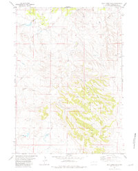
1981 Map of Buck Creek Hills
USGS Topo · Published 1981About this map
The Buck Creek Hills define the topography of this high plains region in Niobrara County, where a complex network of seasonal drainages and draws carves through the landscape. The drainage patterns of Swede Draw, Peddy Draw, and Hancock Draw indicate a terrain shaped by intermittent water flow, essential for the local livestock and ranching economy. This 1981 edition shows the intersection of natural water sources like Lance Creek and Buck Creek with modern industrial infrastructure, such as the Pipeline that traverses the northern sections. Grounded details such as various Spring and Springs locations, along with numerous sites marked as Well and Drill Hole, suggest active resource exploration and water management in this Wyoming interior. Smaller landmarks like Beaver Hole Draw and Hancock provide specific reference points for researchers tracing historical land use and environmental changes.
Find a feature on this map
14 named features on this map. Tap any name to fly to it.
Don’t see what you’re looking for? This feature index may not catch every label — zoom into the map to look around manually.
Map Details
Editions of this 1981 Buck Creek Hills Map
This is the sole edition of this map. No revisions or reprints were ever made.
Other maps of this area

1955 · Newcastle
USGS Topo · 1:250,000

1958 · Newcastle
USGS Topo · 1:250,000

1981 · Telephone Draw
USGS Topo · 1:24,000
1981 · Rabbit Mountains
USGS Topo · 1:24,000
1981 · Coyote Gap
USGS Topo · 1:24,000
1981 · Redbird
USGS Topo · 1:24,000
1981 · Bowen Flat
USGS Topo · 1:24,000
1981 · Boggy Reservoir
USGS Topo · 1:24,000
1981 · Funny Rock
USGS Topo · 1:24,000
1981 · Greasewood Creek
USGS Topo · 1:24,000