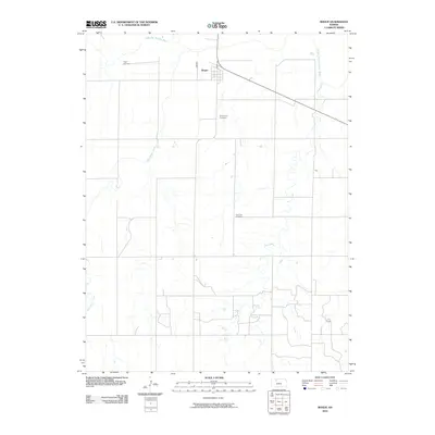
2010 Map of Bogue
USGS Topo · Published 2010About this map
Bogue serves as the primary settlement in this Western Kansas landscape, situated near the northern edge where Main St anchors the small grid of the town. The geography is defined by the drainage patterns of the South Fork Solomon River, which winds through the northern portion of the quadrangle. Local family history and genealogy are centered on three distinct burial grounds: Fagan Cemetery to the west of town, Wild Horse Cemetery to the south, and Samuels Cemetery further into the interior. These sites, along with the paths of Sand Creek and Wild Horse Creek, trace the rural development of Graham County. The map illustrates a classic Great Plains section-line road network, showing how the land was partitioned for agriculture and grazing around these essential water sources.
Find a feature on this map
8 named features on this map. Tap any name to fly to it.
Don’t see what you’re looking for? This feature index may not catch every label — zoom into the map to look around manually.
Map Details
Editions of this 2010 Bogue Map
This is the sole edition of this map. No revisions or reprints were ever made.
Other maps of this area

1893 · Hill
USGS Topo · 1:125,000

1955 · Beloit
USGS Topo · 1:250,000

1959 · Beloit
USGS Topo · 1:250,000

1969 · Nicodemus
USGS Topo · 1:24,000

1969 · Palco
USGS Topo · 1:24,000

1979 · Bogue
USGS Topo · 1:24,000

1979 · Hill City South
USGS Topo · 1:24,000
1979 · Hill City 4 NW
USGS Topo · 1:24,000
1979 · Bogue NW
USGS Topo · 1:24,000
1979 · Wild Horse Creek
USGS Topo · 1:24,000