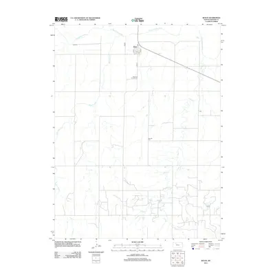
2012 Map of Bogue
USGS Topo · Published 2012About this map
The Bogue townsite occupies the high ground south of the S Fork Solomon River in Graham County, organized around a traditional street grid including Main St and H Ave. This 2012 survey reveals an agricultural landscape carved by a network of drainage systems, with Wild Horse Cr and Sand Cr winding through the southern and eastern sections of the quadrangle. For those researching local families and early prairie settlements, the map provides precise locations for three distinct burial grounds: Fagan Cem to the northwest, Wild Horse Township Cem situated just south of the main settlement, and Samuels Cem located further east near the creek bends. The road network follows the section lines of the Public Land Survey System, a hallmark of the Kansas plains, which dictates the spatial distribution of homesteads and farmsteads throughout the territory.
Find a feature on this map
13 named features on this map. Tap any name to fly to it.
Don’t see what you’re looking for? This feature index may not catch every label — zoom into the map to look around manually.
Map Details
Editions of this 2012 Bogue Map
This is the sole edition of this map. No revisions or reprints were ever made.
Other maps of this area

1893 · Hill
USGS Topo · 1:125,000

1955 · Beloit
USGS Topo · 1:250,000

1959 · Beloit
USGS Topo · 1:250,000

1969 · Nicodemus
USGS Topo · 1:24,000

1969 · Palco
USGS Topo · 1:24,000

1979 · Bogue
USGS Topo · 1:24,000

1979 · Hill City South
USGS Topo · 1:24,000
1979 · Hill City 4 NW
USGS Topo · 1:24,000
1979 · Bogue NW
USGS Topo · 1:24,000
1979 · Wild Horse Creek
USGS Topo · 1:24,000