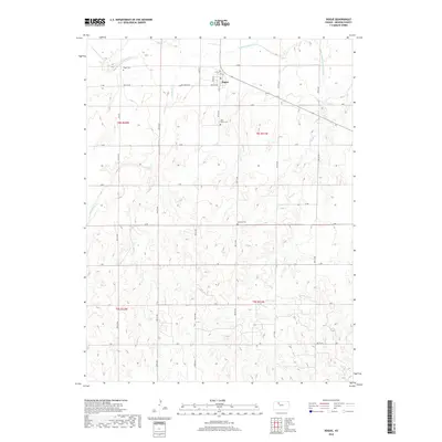
2018 Map of Bogue
USGS Topo · Published 2018About this map
The S Fork Solomon River defines the northern reaches of this Graham County landscape, where the town of Bogue serves as a central hub for the surrounding agricultural community. The terrain is deeply etched by watercourses like Wild Horse Cr and Sand Cr, creating a complex network of draws and ridges that dictated the placement of local roads and farmsteads. For those researching family history in the region, the map identifies several key burial sites including Fagan Cem to the northwest, Wild Horse Cem near the river, and Samuels Cem further south. The surveyor's grid is meticulously preserved through the naming of rural thoroughfares such as Old Bogue Rd and K Rd, illustrating the transition from historic trails to the modern sectional road system that supports the local economy.
Find a feature on this map
26 named features on this map. Tap any name to fly to it.
Don’t see what you’re looking for? This feature index may not catch every label — zoom into the map to look around manually.
Map Details
Editions of this 2018 Bogue Map
This is the sole edition of this map. No revisions or reprints were ever made.
Other maps of this area

1893 · Hill
USGS Topo · 1:125,000

1955 · Beloit
USGS Topo · 1:250,000

1959 · Beloit
USGS Topo · 1:250,000

1969 · Nicodemus
USGS Topo · 1:24,000

1969 · Palco
USGS Topo · 1:24,000

1979 · Bogue
USGS Topo · 1:24,000

1979 · Hill City South
USGS Topo · 1:24,000
1979 · Hill City 4 NW
USGS Topo · 1:24,000
1979 · Bogue NW
USGS Topo · 1:24,000
1979 · Wild Horse Creek
USGS Topo · 1:24,000