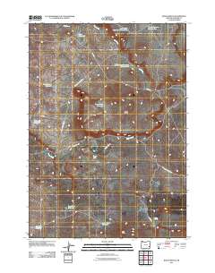
2011 Map of Bogus Bench
USGS Topo · Published 2011About this map
Bogus Bench defines the central topography of this Malheur County landscape, where volcanic history is written into the naming of features like West Crater and Lava Sinks Reservoir. This high-desert environment is characterized by a complex network of man-made water storage, essential for ranching and land management. These include the Indian Camp Reservoir, Cave Reservoir, and the tiered systems of Mud Creek Reservoir Number One and Deer Butte Reservoir Number Two. The reliance on surface water management is further evidenced by long-standing ranch roads such as Miller Ln and Stitzel Rd, which connect remote catchments across the plateau. The drainage pattern of Bogus Creek and Mud Creek dictates the placement of these vital reservoirs, reflecting the localized geography of water access in eastern Oregon.
Find a feature on this map
20 named features on this map. Tap any name to fly to it.
Don’t see what you’re looking for? This feature index may not catch every label — zoom into the map to look around manually.
Map Details
Editions of this 2011 Bogus Bench Map
This is the sole edition of this map. No revisions or reprints were ever made.
Other maps of this area

1955 · Jordan Valley
USGS Topo · 1:250,000

1955 · Boise
USGS Topo · 1:250,000

1957 · Jordan Valley
USGS Topo · 1:250,000

1958 · Boise
USGS Topo · 1:250,000

1958 · Jordan Valley
USGS Topo · 1:250,000

1962 · Boise
USGS Topo · 1:250,000

1969 · Jordan Craters South
USGS Topo · 1:24,000

1969 · Jordan Craters North
USGS Topo · 1:24,000
1969 · Threemile Hill
USGS Topo · 1:24,000

1972 · Owyhee Butte
USGS Topo · 1:24,000