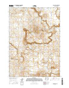
2017 Map of Bogus Bench
USGS Topo · Published 2017About this map
Bogus Bench and the steep escarpment of Bogus Rim define this portion of the high desert in Malheur County, Oregon. This landscape is a complex network of volcanic features and vital water management, where the topography is dotted with numerous small impoundments such as Lava Sinks Reservoir and Little Crater Reservoir. The presence of West Crater speaks to the area's geologic origins, while several named springs and catchments like Venta Spring and Ten Year Reservoir highlight the precarious nature of water in this arid environment. Roads like Miller Ln and Mud Lake Reservoir Rd provide access through the sections of T28S and T29S, connecting various livestock-watering sites such as Indian Camp Reservoir and Bogus Bench Reservoir. The map illustrates a ranching landscape where every drainage, including Mud Cr and its associated reservoirs, is harnessed to support activity on the bench.
Find a feature on this map
25 named features on this map. Tap any name to fly to it.
Don’t see what you’re looking for? This feature index may not catch every label — zoom into the map to look around manually.
Map Details
Editions of this 2017 Bogus Bench Map
This is the sole edition of this map. No revisions or reprints were ever made.
Other maps of this area

1955 · Jordan Valley
USGS Topo · 1:250,000

1955 · Boise
USGS Topo · 1:250,000

1957 · Jordan Valley
USGS Topo · 1:250,000

1958 · Boise
USGS Topo · 1:250,000

1958 · Jordan Valley
USGS Topo · 1:250,000

1962 · Boise
USGS Topo · 1:250,000

1969 · Jordan Craters South
USGS Topo · 1:24,000

1969 · Jordan Craters North
USGS Topo · 1:24,000
1969 · Threemile Hill
USGS Topo · 1:24,000

1972 · Owyhee Butte
USGS Topo · 1:24,000