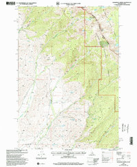
1997 Map of Bohannon Spring
USGS Topo · Published 2002About this map
Beaverhead Mountains and the Continental Divide define this high-altitude landscape along the Idaho Montana border during the late 1990s. The region is marked by a complex hydrological network where Bohannon Creek and Geertson Creek gather from numerous named sources like Magpie Spring No 2 and Bohannon Spring. This area within the Salmon National Forest and Beaverhead National Forest reveals a history of resource exploration, evidenced by scattered Prospect and Adit labels throughout the slopes. The map also captures the distinct alpine terrain of Sacajawea Peaks and Center Mountain, with remote 4wd tracks providing the only interior access. Notable for genealogists and local historians are the specifically named landmarks such as Chet Royce Spring and Albertson Spring, which often indicate family-held grazing allotments or historic mountain camps.
Find a feature on this map
36 named features on this map. Tap any name to fly to it.
Don’t see what you’re looking for? This feature index may not catch every label — zoom into the map to look around manually.
Map Details
Editions of this 1997 Bohannon Spring Map
This is the sole edition of this map. No revisions or reprints were ever made.
Other maps of this area

1950 · Salmon
USGS Topo · 1:62,500

1951 · Salmon
USGS Topo · 1:62,500

1955 · Dillon
USGS Topo · 1:250,000

1956 · Goldstone Mtn
USGS Topo · 1:62,500

1957 · Dillon
USGS Topo · 1:250,000

1958 · Dillon
USGS Topo · 1:250,000

1962 · Dillon
USGS Topo · 1:250,000

1965 · Dillon
USGS Topo · 1:250,000

1966 · Badger Spring Gulch
USGS Topo · 1:24,000

1966 · Miner Lake
USGS Topo · 1:24,000