
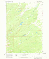
1966 Map of Miner Lake
USGS Topo · Published 1970About this map
Beaverhead National Forest defines this high-elevation landscape, where a network of drainages and pack routes supported back-country access in the mid-1960s. The topography is anchored by Miner Lake and its associated Campground, serving as a central hub for those navigating the surrounding peaks. To the south, the terrain opens into Berry Meadow near the confluence of several mountain streams.
Find a feature on this map
18 named features on this map. Tap any name to fly to it.
Don’t see what you’re looking for? This feature index may not catch every label — zoom into the map to look around manually.
Map Details
Editions of this 1966 Miner Lake Map
2 editions found
Other maps of this area

1955 · Dillon
USGS Topo · 1:250,000

1956 · Goldstone Mtn
USGS Topo · 1:62,500

1957 · Dillon
USGS Topo · 1:250,000

1958 · Dillon
USGS Topo · 1:250,000

1962 · Dillon
USGS Topo · 1:250,000

1965 · Dillon
USGS Topo · 1:250,000

1966 · Jumbo Mountain
USGS Topo · 1:24,000
1966 · Ajax Ranch
USGS Topo · 1:24,000
1966 · Homer Youngs Peak
USGS Topo · 1:24,000
1978 · Jackson
USGS Topo · 1:24,000