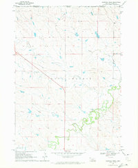
1970 Map of Bohemian Creek
USGS Topo · Published 1972About this map
The White River winds through the southern reaches of this Nebraska landscape, where the high plains meet the intricate drainage systems of West Chadron. This 1970 field-checked survey reveals a quiet, open terrain defined by the winding paths of Bohemian Creek, Rush Creek, and Madden Creek. The presence of several Gravel Pits and Gravel Pit locations suggests the local importance of aggregate mining for regional infrastructure during this era. Straddling the border between Dawes County and South Dakota, the map documents a sparse settlement pattern dominated by large agricultural tracts and basic roadway networks like Route 385. Researchers will find a network of section lines and fence markings that delineate the ranching and farming boundaries of the northwestern Nebraska panhandle.
Find a feature on this map
11 named features on this map. Tap any name to fly to it.
Don’t see what you’re looking for? This feature index may not catch every label — zoom into the map to look around manually.
Map Details
Editions of this 1970 Bohemian Creek Map
This is the sole edition of this map. No revisions or reprints were ever made.
Other maps of this area

1896 · Oelrichs
USGS Topo · 1:125,000

1900 · Oelrichs
USGS Topo · 1:125,000

1955 · Hot Springs
USGS Topo · 1:250,000

1955 · Alliance
USGS Topo · 1:250,000

1957 · Alliance
USGS Topo · 1:250,000

1958 · Alliance
USGS Topo · 1:250,000

1967 · Slim Butte SW
USGS Topo · 1:24,000
1970 · Chadron East
USGS Topo · 1:24,000
1970 · Isinglass Buttes
USGS Topo · 1:24,000

1980 · Wayside
USGS Topo · 1:24,000