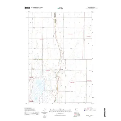
2019 Map of Boisberg
USGS Topo · Published 2019About this map
The Bois de Sioux River forms the winding natural border where North Dakota, South Dakota, and Minnesota meet, anchoring a landscape defined by its tristate geography. This prairie region is marked by small settlements like White Rock and Boisberg, which sit near the intersection of Roberts and Traverse counties. The terrain is dotted with significant water bodies such as East Clubhouse Lake and Mollison Lake, illustrating the glacial lake heritage of the Red River Valley. Local history is etched into the landscape at Lake View Cem and the northern settlement of Blackmer. A dense grid of rural roads, including Co Hwy 16 and 102nd St SE, connects these remote outposts across the state lines, reflecting the organized agricultural layout of the early 21st century.
Find a feature on this map
60 named features on this map. Tap any name to fly to it.
Don’t see what you’re looking for? This feature index may not catch every label — zoom into the map to look around manually.
Map Details
Editions of this 2019 Boisberg Map
This is the sole edition of this map. No revisions or reprints were ever made.
Other maps of this area

1904 · Wahpeton
USGS Topo · 1:125,000

1915 · White Rock
USGS Topo · 1:62,500

1918 · White Rock
USGS Topo · 1:62,500

1951 · Wheaton
USGS Topo · 1:62,500

1951 · Campbell
USGS Topo · 1:62,500

1953 · Milbank
USGS Topo · 1:250,000

1953 · Fargo
USGS Topo · 1:250,000

1956 · Fargo
USGS Topo · 1:250,000

1958 · Milbank
USGS Topo · 1:250,000
1972 · La Mars
USGS Topo · 1:24,000