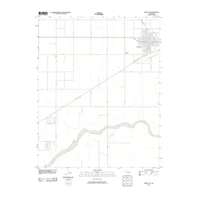
2010 Map of Boise City
USGS Topo · Published 2010About this map
Boise City serves as the focal point of this Oklahoma panhandle survey, appearing as a concentrated grid of streets and developments in the high plains. The town's layout is centered around several major corridors, including Wilson St, while the surrounding landscape is partitioned into the expansive rectilinear grid system characteristic of Cimarron County. To the southwest of the main settlement, the Boise City Cemetery stands along E0200 Rd, providing a specific point of interest for genealogists and local historians tracking family sites in the region.
Find a feature on this map
20 named features on this map. Tap any name to fly to it.
Don’t see what you’re looking for? This feature index may not catch every label — zoom into the map to look around manually.
Map Details
Editions of this 2010 Boise City Map
This is the sole edition of this map. No revisions or reprints were ever made.
Other maps of this area

1954 · Dalhart
USGS Topo · 1:250,000

1958 · Dalhart
USGS Topo · 1:250,000

1962 · Dalhart
USGS Topo · 1:250,000

1969 · Boise City
USGS Topo · 1:24,000

1969 · Boise City NW
USGS Topo · 1:24,000

1969 · Boise City SW
USGS Topo · 1:24,000

1969 · Flagg Springs
USGS Topo · 1:24,000

1969 · Boise City SE
USGS Topo · 1:24,000
1969 · Autograph Cliff
USGS Topo · 1:24,000

1971 · Keyes SW
USGS Topo · 1:24,000