
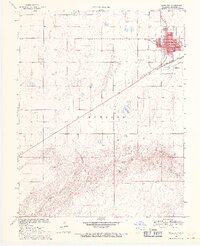
1969 Map of Boise City
USGS Topo · Published 1971About this map
Boise City serves as a prominent hub in the Oklahoma Panhandle, its town grid centered around the Courthouse and public services like the Library, Hospital, and Po. The late 1960s landscape shows a community defined by its proximity to both the Santa Fe and Atchison Topeka railroad and the natural course of the North Canadian River to the south. This survey captures the town’s civic infrastructure in detail, from the High Sch and City Hall to the Boise City Cem on the eastern outskirts. The terrain transitions from the developed streets of the county seat to the open grazing lands and breaks of the Cleveland township, where the river valley carves through the High Plains. The map provides a precise look at the mid-century development of this intersection of rail and road, documenting landmarks like the Radio Tower and local recreation at the Golf Course.
Find a feature on this map
15 named features on this map. Tap any name to fly to it.
Don’t see what you’re looking for? This feature index may not catch every label — zoom into the map to look around manually.
Map Details
Editions of this 1969 Boise City Map
2 editions found
Other maps of this area

1954 · Dalhart
USGS Topo · 1:250,000

1958 · Dalhart
USGS Topo · 1:250,000

1962 · Dalhart
USGS Topo · 1:250,000

1969 · Boise City NW
USGS Topo · 1:24,000

1969 · Boise City SW
USGS Topo · 1:24,000

1969 · Flagg Springs
USGS Topo · 1:24,000

1969 · Boise City SE
USGS Topo · 1:24,000
1969 · Autograph Cliff
USGS Topo · 1:24,000

1971 · Keyes SW
USGS Topo · 1:24,000

1971 · Conrad NW
USGS Topo · 1:24,000