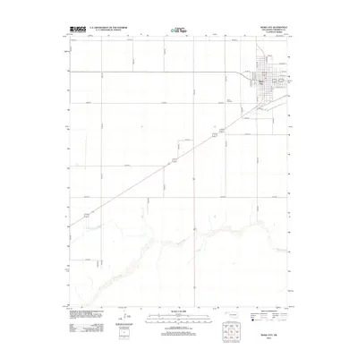
2012 Map of Boise City
USGS Topo · Published 2012About this map
Boise City serves as the focal point of this Cimarron County landscape, situated within a high-plains grid of section roads. The town's residential and commercial core is defined by a series of north-south thoroughfares, including Pipkin Ave, Balfour Ave, and Logan Ave. To the west, the Boise City Cem sits along the roadway, marking a significant local landmark for genealogical study. The southern portion of the quadrangle is defined by the winding course of the Beaver River, which provides a natural break in the otherwise regular geometry of the surveyed terrain. This intersection of a strictly planned agricultural and municipal grid with the riparian corridor of the river illustrates the environmental constraints and adaptations of a community in the Oklahoma Panhandle.
Find a feature on this map
36 named features on this map. Tap any name to fly to it.
Don’t see what you’re looking for? This feature index may not catch every label — zoom into the map to look around manually.
Map Details
Editions of this 2012 Boise City Map
This is the sole edition of this map. No revisions or reprints were ever made.
Other maps of this area

1954 · Dalhart
USGS Topo · 1:250,000

1958 · Dalhart
USGS Topo · 1:250,000

1962 · Dalhart
USGS Topo · 1:250,000

1969 · Boise City
USGS Topo · 1:24,000

1969 · Boise City NW
USGS Topo · 1:24,000

1969 · Boise City SW
USGS Topo · 1:24,000

1969 · Flagg Springs
USGS Topo · 1:24,000

1969 · Boise City SE
USGS Topo · 1:24,000
1969 · Autograph Cliff
USGS Topo · 1:24,000

1971 · Keyes SW
USGS Topo · 1:24,000