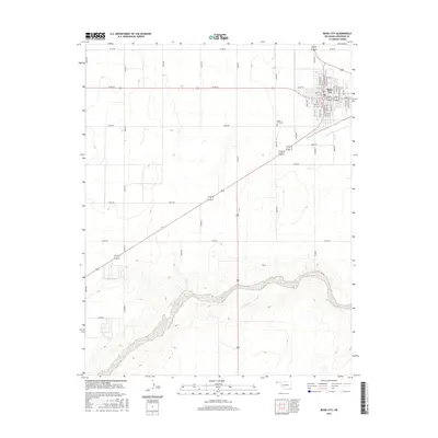
2016 Map of Boise City
USGS Topo · Published 2016About this map
Boise City serves as the focal point of this Cimarron County survey, situated at the crossroads of several regional highways in the Oklahoma Panhandle. The town’s grid is clearly defined by residential and commercial avenues, including Cimarron Ave and Texas Ave. To the southwest, the Beaver River meanders across the high plains, its wide corridor contrasting with the rigid section-line road network that dominates the surrounding landscape. The placement of the Boise City Cem on the outskirts provides a point of interest for genealogists tracing local families. This map illustrates the intersection of a mid-century town structure with the expansive, sparsely populated agricultural lands typical of this region, where long-distance travel relies on a grid of numbered section roads like N0250 Rd and E0190 Rd.
Find a feature on this map
49 named features on this map. Tap any name to fly to it.
Don’t see what you’re looking for? This feature index may not catch every label — zoom into the map to look around manually.
Map Details
Editions of this 2016 Boise City Map
This is the sole edition of this map. No revisions or reprints were ever made.
Other maps of this area

1954 · Dalhart
USGS Topo · 1:250,000

1958 · Dalhart
USGS Topo · 1:250,000

1962 · Dalhart
USGS Topo · 1:250,000

1969 · Boise City
USGS Topo · 1:24,000

1969 · Boise City NW
USGS Topo · 1:24,000

1969 · Boise City SW
USGS Topo · 1:24,000

1969 · Flagg Springs
USGS Topo · 1:24,000

1969 · Boise City SE
USGS Topo · 1:24,000
1969 · Autograph Cliff
USGS Topo · 1:24,000

1971 · Keyes SW
USGS Topo · 1:24,000