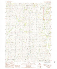
1984 Map of Bolckow NW
USGS Topo · Published 1985About this map
Nodaway County and Andrew County meet along a rural Missouri landscape defined by a dense network of watercourses and agricultural divisions. The township boundaries of Hughes, White Cloud, Clay, and Benton organize the terrain, which is drained by the winding paths of White Cloud Creek, Jenkins Creek, and the East Fork of the Platte River system. Several unnamed Cem locations suggest long-established family burial plots or church sites integrated into the rural fabric. Modern infrastructure is represented by a north-south Wooden Pole Trans Line and a prominent Pipeline, while a small Levee along the East Fork indicates local water management efforts. This provisional study captures the transition of the high prairie into the dissected stream valleys of the Missouri River watershed during the early 1980s.
Find a feature on this map
15 named features on this map. Tap any name to fly to it.
Don’t see what you’re looking for? This feature index may not catch every label — zoom into the map to look around manually.
Map Details
Editions of this 1984 Bolckow NW Map
This is the sole edition of this map. No revisions or reprints were ever made.
Other maps of this area

1926 · Maitland
USGS Topo · 1:62,500

1927 · Bolckow
USGS Topo · 1:62,500

1939 · Skidmore
USGS Topo · 1:62,500

1941 · Skidmore
USGS Topo · 1:62,500

1942 · Skidmore
USGS Topo · 1:62,500

1943 · Maryville
USGS Topo · 1:62,500

1945 · Bolckow
USGS Topo · 1:62,500

1955 · Nebraska City
USGS Topo · 1:250,000

1957 · Nebraska City
USGS Topo · 1:250,000

1958 · Nebraska City
USGS Topo · 1:250,000