
1945 Map of Bolckow
USGS Topo · Published 1945About this map
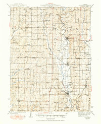
Barnard and Bolckow serve as primary rail hubs in this mid-century portrait of northwest Missouri, where the Chicago Burlington and Quincy railroad follows the winding course of the Hundred and Two River. The map reveals a densely settled rural landscape defined by an exceptional number of small district schools and country churches, reflecting the community structure of Andrew Co and Nodaway Co before school consolidation. Notable landmarks such as Pumpkin Center and the Common Sense Sch highlight local vernacular naming, while the Chicago Great Western line cuts through the eastern portion near Rea and Wyeth. This survey, based on field work by F.L.Whaley and others, provides a detailed view of the region's agricultural layout, from the Platte River valley to the western settlements of Fillmore and Antioch Ch.
Find a feature on this map
78 named features on this map. Tap any name to fly to it.
Don’t see what you’re looking for? This feature index may not catch every label — zoom into the map to look around manually.
Map Details
Editions of this 1945 Bolckow Map
2 editions found
Other maps of this area

1885 · Atchison
USGS Topo · 1:125,000

1888 · Atchison
USGS Topo · 1:125,000

1893 · Atchison
USGS Topo · 1:125,000

1923 · Clarksdale
USGS Topo · 1:62,500

1924 · St. Joseph
USGS Topo · 1:62,500

1925 · Clarksdale
USGS Topo · 1:62,500

1925 · Stanberry
USGS Topo · 1:62,500

1926 · Saint Joseph
USGS Topo · 1:62,500

1926 · Oregon
USGS Topo · 1:62,500

1926 · Maitland
USGS Topo · 1:62,500