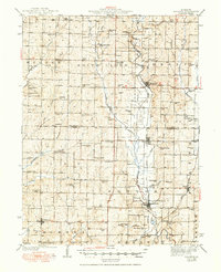
1945 Map of Bolckow
USGS Topo · Published 1950About this map
The Hundred and Two River and the Platte River wind through the borderlands of Nodaway and Andrew counties, defining a landscape of agriculture and community as it stood in the late 1940s. The region is characterized by a dense network of local institutions, including the uniquely named Common Sense Sch and numerous country churches like Prairie Temple Ch. Rail transport is central to the area's geography, with the Chicago Burlington and Quincy line serving Barnard, Bolckow, and Rosendale, while the Chicago Great Western passes through Wyeth.
Find a feature on this map
87 named features on this map. Tap any name to fly to it.
Don’t see what you’re looking for? This feature index may not catch every label — zoom into the map to look around manually.
Map Details
Editions of this 1945 Bolckow Map
2 editions found

Other maps of this area

1885 · Atchison
USGS Topo · 1:125,000

1888 · Atchison
USGS Topo · 1:125,000

1893 · Atchison
USGS Topo · 1:125,000

1923 · Clarksdale
USGS Topo · 1:62,500

1924 · St. Joseph
USGS Topo · 1:62,500

1925 · Clarksdale
USGS Topo · 1:62,500

1925 · Stanberry
USGS Topo · 1:62,500

1926 · Saint Joseph
USGS Topo · 1:62,500

1926 · Oregon
USGS Topo · 1:62,500

1926 · Maitland
USGS Topo · 1:62,500