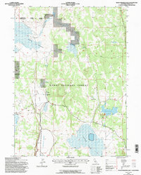
1993 Map of Boles Meadow East
USGS Topo · Published 1996About this map
XL Ranch and the adjacent Indian Reservation anchor the western edge of this High Desert landscape, where ranching history and federal land management intersect. This 1993 revision, based on photographs dating back to 1958, illustrates a complex water management system essential for life in the Modoc National Forest. A network of artificial catchments like Reservoir G, Reservoir C, and West Black Rock Reservoir support the surrounding terrain, while an extensive Levee system defines the southern reaches near Antelope Plains.
Find a feature on this map
26 named features on this map. Tap any name to fly to it.
Don’t see what you’re looking for? This feature index may not catch every label — zoom into the map to look around manually.
Map Details
Editions of this 1993 Boles Meadow East Map
This is the sole edition of this map. No revisions or reprints were ever made.
Other maps of this area

1886 · Alturas
USGS Topo · 1:250,000

1892 · Alturas
USGS Topo · 1:250,000

1954 · Alturas
USGS Topo · 1:250,000

1958 · Alturas
USGS Topo · 1:250,000

1962 · Alturas
USGS Topo · 1:250,000

1962 · Big Sage Reservoir
USGS Topo · 1:62,500

1962 · Steele Swamp
USGS Topo · 1:62,500

1962 · South Mountain
USGS Topo · 1:62,500

1962 · Jacks Butte
USGS Topo · 1:62,500

1965 · Alturas
USGS Topo · 1:250,000