
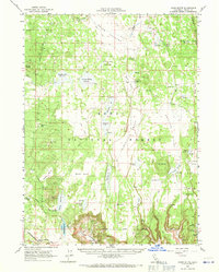
1962 Map of Jacks Butte
USGS Topo · Published 1964About this map
The XL Ranch Indian Reservation occupies a central portion of this 1962 terrain, where high-altitude livestock ranching and water management define the landscape. Scattered homesteads such as Round Valley Ranch and Bacon Ranch are connected by primitive paths like Mowitz Road and Tickner Road, reflecting a sparse settlement pattern tied to the region's meadows. A complex network of artificial water sources, including Deadhorse Flat Reservoir and Surveyors Valley Reservoir, illustrates the critical infrastructure needed for cattle in the Modoc National Forest.
Find a feature on this map
56 named features on this map. Tap any name to fly to it.
Don’t see what you’re looking for? This feature index may not catch every label — zoom into the map to look around manually.
Map Details
Editions of this 1962 Jacks Butte Map
2 editions found
Other maps of this area

1886 · Alturas
USGS Topo · 1:250,000

1886 · Modoc Lava Bed
USGS Topo · 1:250,000

1892 · Modoc Lava-Bed
USGS Topo · 1:250,000

1892 · Alturas
USGS Topo · 1:250,000

1951 · Clear Lake Reservoir
USGS Topo · 1:62,500

1952 · Hackamore
USGS Topo · 1:62,500

1954 · Alturas
USGS Topo · 1:250,000

1958 · Alturas
USGS Topo · 1:250,000

1961 · Canby
USGS Topo · 1:62,500

1961 · Alturas
USGS Topo · 1:62,500