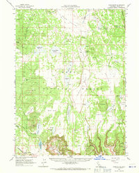
1962 Map of Jacks Butte
USGS Topo · Published 1971About this map
XL Ranch Indian Reservation sits at the heart of this high-altitude landscape, illustrating the complex land use patterns of northeastern California. The terrain is characterized by a high concentration of water management features, including the MDOC Reservoirs, Deadhorse Flat Reservoir, and the Surveyors Valley Reservoir, which suggest a landscape heavily utilized for ranching and seasonal grazing. Small settlements and family operations like Round Valley Ranch and Hastings Ranch are linked by a network of unimproved roads and jeep trails, while the Southern Pacific railroad line cuts through the southwestern corner near Ambrose. Natural features like Boles Meadows and Fairchild Swamp punctuate the Modoc National Forest, defining the drainage patterns through Round Valley and the Antelope Plains. The presence of several tanks and springs, such as Essex Spring and Six-Shooter Tank, underscores the importance of water security in this volcanic plateau region.
Find a feature on this map
68 named features on this map. Tap any name to fly to it.
Don’t see what you’re looking for? This feature index may not catch every label — zoom into the map to look around manually.
Map Details
Editions of this 1962 Jacks Butte Map
2 editions found

Other maps of this area

1886 · Alturas
USGS Topo · 1:250,000

1886 · Modoc Lava Bed
USGS Topo · 1:250,000

1892 · Modoc Lava-Bed
USGS Topo · 1:250,000

1892 · Alturas
USGS Topo · 1:250,000

1951 · Clear Lake Reservoir
USGS Topo · 1:62,500

1952 · Hackamore
USGS Topo · 1:62,500

1954 · Alturas
USGS Topo · 1:250,000

1958 · Alturas
USGS Topo · 1:250,000

1961 · Canby
USGS Topo · 1:62,500

1961 · Alturas
USGS Topo · 1:62,500