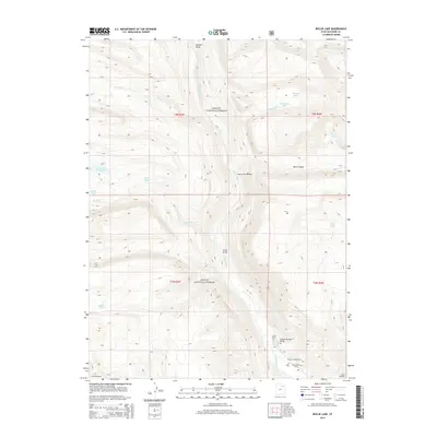
2014 Map of Bollie Lake
USGS Topo · Published 2014About this map
The Uinta River carves through the heart of the Ashley National Forest in this 2014 survey, illustrating a landscape defined by high-elevation hydrology and recreation. Access to this territory is marked by a series of crossings, including the Rock Canyon Bridge, Sheep Bridge, and the Uinta Spring Bridge near the southern boundary. These structures facilitate movement through the drainage basins of Atwood Creek and Krebs Creek, connecting isolated outposts like the U-Bar Ranch with higher alpine terrain.
Find a feature on this map
29 named features on this map. Tap any name to fly to it.
Don’t see what you’re looking for? This feature index may not catch every label — zoom into the map to look around manually.
Map Details
Editions of this 2014 Bollie Lake Map
This is the sole edition of this map. No revisions or reprints were ever made.
Other maps of this area

1885 · Uinta
USGS Topo · 1:250,000

1905 · Gilbert Peak
USGS Topo · 1:125,000

1906 · Gilbert Peak
USGS Topo · 1:125,000

1954 · Salt Lake City
USGS Topo · 1:250,000

1958 · Salt Lake City
USGS Topo · 1:250,000

1960 · Salt Lake City
USGS Topo · 1:250,000
1965 · Rasmussen Lakes
USGS Topo · 1:24,000
1965 · Pole Creek Cave
USGS Topo · 1:24,000

1965 · Mount Emmons
USGS Topo · 1:24,000
1965 · Heller Lake
USGS Topo · 1:24,000