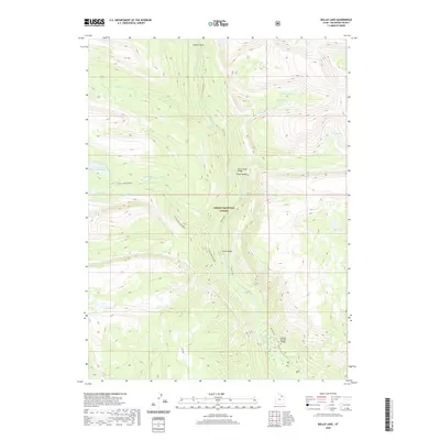
2020 Map of Bollie Lake
USGS Topo · Published 2020About this map
Ashley National Forest encompasses this high-elevation landscape, where the Uinta River carves through deep canyons and connects a network of alpine basins. The map illustrates a remote wilderness defined by water and foot travel, particularly along the Chain Lakes-Atwood trail system which links a series of glacial lakes including Lower Chain Lake, Lily Lake, and Island Lake. Significant river crossings are documented at Rock Canyon Bridge, Sheep Bridge, and the Smokey Springs Bridge near the southern boundary.
Find a feature on this map
22 named features on this map. Tap any name to fly to it.
Don’t see what you’re looking for? This feature index may not catch every label — zoom into the map to look around manually.
Map Details
Editions of this 2020 Bollie Lake Map
This is the sole edition of this map. No revisions or reprints were ever made.
Other maps of this area

1885 · Uinta
USGS Topo · 1:250,000

1905 · Gilbert Peak
USGS Topo · 1:125,000

1906 · Gilbert Peak
USGS Topo · 1:125,000

1954 · Salt Lake City
USGS Topo · 1:250,000

1958 · Salt Lake City
USGS Topo · 1:250,000

1960 · Salt Lake City
USGS Topo · 1:250,000
1965 · Rasmussen Lakes
USGS Topo · 1:24,000
1965 · Pole Creek Cave
USGS Topo · 1:24,000

1965 · Mount Emmons
USGS Topo · 1:24,000
1965 · Heller Lake
USGS Topo · 1:24,000